
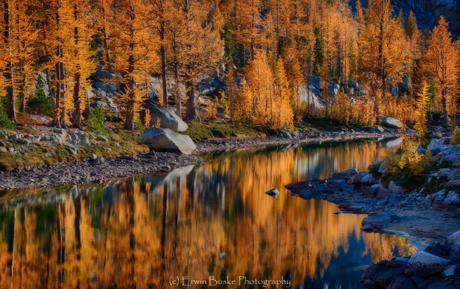
The Enchantments are calling! This in an enchanted land of beautiful azurite and indigo blue high mountain lakes with names like Leprechaun, Perfection, Inspiration, and Temple Lakes. In Autumn, stunningly beautiful larch trees turn bright orange colors that glow in soft luminous light. Large peaks made up of huge slabs of granite with names like Prusik, McClellan, and Little Annapurna rise high above the lakes and are reflected beautifully into the calm waters as the sun rises and sets. The granite rocks around the lakes almost look like they were placed there by the Gods to create leading lines and curves to transport us into the beauty of each lake and the surrounding landscape. This in short is a photographer’s paradise, as close to heaven on earth as we will get in our mortal lives.
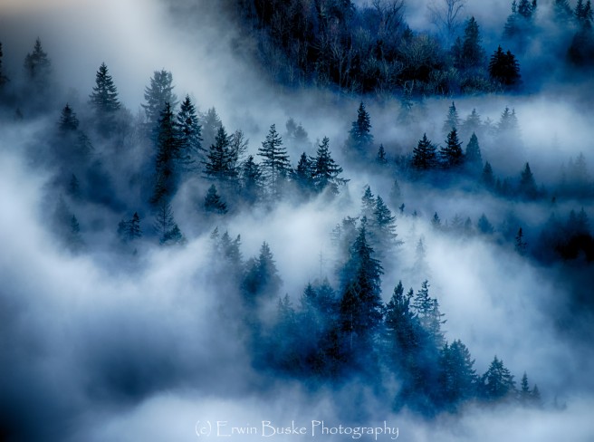
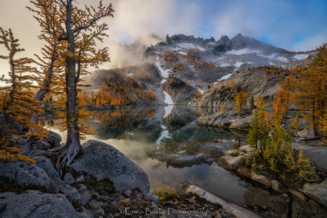
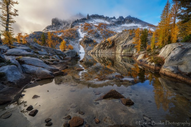
 Larches in the Enchanted Mists
The Enchantments are located in the northeastern section of Washington State’s Alpine Lakes Wilderness Area, USA, close to the town of Leavenworth. I consider the Enchantments are one of the wonders of this world and I harbor great memories of these beautiful blue and rock-bound lakes spanning the last four decades of my life. I have made a journey to this iconic site about every ten years since my late teens. When I received an email notice in CY 2015 that I had won the Enchantments Lottery I was totally stoked! This time the trip felt like a return journey, somewhat like a spiritual pilgrimage to my roots–a pristine wilderness that has helped shape my photographic journey. With permit in hand, I organized a six-day backpacking trip as a photography oriented trip through the Seattle Mountaineers. Photography backpacks are much different from a typical organized backpacking trip. The pace and tempo of this trip is centered around photography. This meant frequent stops along the trail and organizing our schedule to be at the right places for at least a two to three hours window around sunrise and sunset. I deliberately kept the number of participants at a small number, five, to make sure each of the photographers had a quality experience and were not stepping over each other trying to get the image. Participants were also carefully screened as this is a physically challenging backpack.
I was even more thrilled the following year when a friend, Kris Harken, reached out to me with an invitation to join his team to visit the Enchantments once more in CY 2016. This time I could capture all those compositions I realized I missed in the previous year! I think it would take multiple lifetimes of annual trips to fully capture the beauty of the Enchantment, this area abounds in so much nuanced beauty. On the last trip we were forced to leave early due to heavy and unrelenting snow so I did not shoot all the site I had previsualized. Hopefully I will return to the Enchantments soon or perhaps in my next life!

Leprechaun Lake
In this post I will discuss visiting and photographing the Enchantments in Autumn including the following topics: Getting a Permit, Route, Conditioning, Cold Weather Preparations, Importance of Packing Light, Camera Gear, Compositions, Light, Wildlife, Larches, and the Magic of the Enchantments.
Getting a Permit
Going to the Enchantments requires a permit for overnight camping. This requirement is strictly enforced by the Forest Service to reduce the environmental impact that comes with too many people loving this place to death. From the Okanogan Wenatchee Forest Website: “Due to the overwhelming popularity of this unique area, all overnight visitors must obtain a limited entry FEE permit for trips planned between May 15 and October 31. Demand for overnight permits far exceeds the number available, therefore advance reservations are highly recommended. A pre-season lottery is held in February through early March of each year to allocate the majority of permits. Following the pre-season lottery, remaining permits are available on a first come, first served basis through the recreation.gov advance reservation system. A small number of permits are available on an unreserved daily walk-in basis.”
Because this area is extremely popular, far more people apply for a permit than there are permits available, especially in Autumn. Only 60 people are allowed in the Core Enchantment area at any one time. The good news, however, is that a permit holder can lead a trip that includes as many as eight people. So even if you are not lucky enough to get a permit, someone you known many be kind enough to invite you on their trip! There are different Enchantment Lakes permit zones and the most desirable one is the Core Enchantment Zone because it allows you to camp at the lower Enchantment Lakes for up to eight nights. Keep in mind that the lower Enchantment Lakes are about 7,000 feet high in elevation and offer the best views of large collections of larches.

Leprechaun Lake Sunrise
Route
For my last two trips to the Enchantments, we entered through the Snow Lake trailhead just outside the Washington town of Leavenworth along the Icicle Creek. The first day we climbed approximately 3,500 feet over five miles to the beautiful deep woods Nada Lake. Then on the next day we hiked past Snow Lakes then scrambled up the steep trail to the Enchantments Leprechaun Lake where we camped for three nights before returning through Nada Lake . Although this route is longer and involves more elevation gain than going over Asgard Pass (the alternative route), generally it involves less steep climbing, traversing through scree and boulder hoping. I love the sense of a journey that one gets taking the route through the Snow Lake trail entrance. Camping at beautiful Nada lake offers a great transition zone between the sub-alpine and alpine helping whet the appetite for even greater beauty ahead.
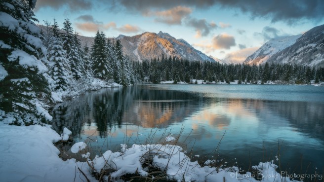
 Nada Lake Outlet
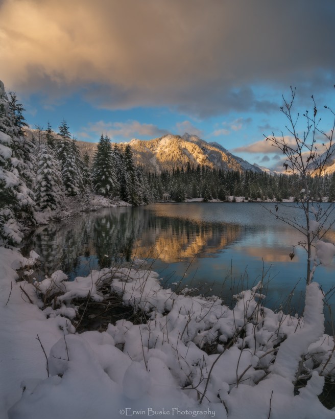
 Nada Lake Sunset
Conditioning
Many people who are lucky enough to get a permit and very surprised at the difficulty of the trip once they embark on their adventure. This multi-day backpacking trip requires extensive conditioning if you are going to enjoy the trip in comfort. Before beginning your journey take multiple day hikes that involve elevation gain in the range of three to five thousand feet, for example in the Seattle area Mail Box, Granite Mountain, and Mt. Washington. Also before launching off, go on a couple of overnight backpacking trips of six miles or more and two to three thousand elevation gain with a backpack in the range of 35 to 45 pounds. There is nothing like actually hiking and backpacking for conditioning, and although time spent at the fitness center helps, this alone will not prepare you for the Enchantments experience.
Cold Weather Preparations
In most years peak season for the larches is the last week of September and the first week of October. Go any earlier and one risks the larches still being partially green. Go later and one risks the larch trees being stripped of their orange needles due to fierce wind storms that pass through the area. Although during this time the Enchantments experience what is known as the Indian Summer with warm days and cool crisp nights under cloudless skies, this is punctuated by storms passing through the area that can bring freezing cold temperatures, dark gray moisture laden clouds, and snow. It is not uncommon to wake up to 2 to 6 inches of snow and temperatures in the teens. This happened on both of my recent trips. So cold weather preparations or in order. This means a four season tent, a sleeping bag that can go down to 15 degrees or below, multiple layers of warmth, head to toe water proof rain/wind gear, gloves, and a warm beanie type hat.
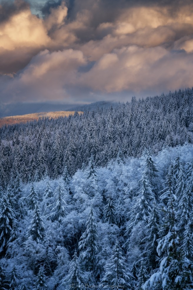
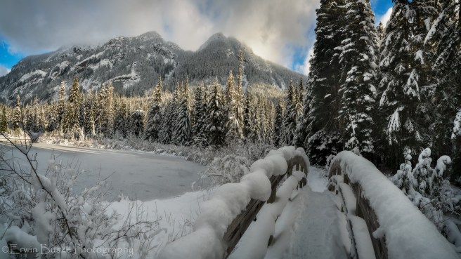
 Fusion of Fall and Winter at the Enchantments
Importance of Packing Light
Maintaining a good comfort level on a multi-day backpacking trip has everything to do with keeping weight of the backpack at a manageable level of between 35 and 45 pounds. This challenge is doubly hard for us photographers because not only do we need to carry extra layers of warm clothing and a four season tent, but also we need to carry camera gear including a tripod. One needs to think carefully through what one brings along because every ounce counts. I strongly recommend to photographers to carry an ultralight sleeping bag, tent, rain gear, clothing etc. But this does not mean accepting significant compromises in functionality. Three season tents will be crushed under the weight of a heavy snowstorm and a sleeping bag that only goes down to 35 degrees will not keep you warm when temperatures dip down into the teens. Ultralight gear can be expensive, but there are deals to be found at the REI Garage, Backcountry.Com and other outlets.
Camera Equipment
My recommendation is to take only two lenses and at the most three. The lens that is most useful at the Enchantments is a wide-angle zoom closely followed by a telephoto zoom. I have never found the need for a standard zoom at the Enchantments except to take candid images of people and an I-phone will work just fine for that. On my last trip I brought a Sony A7R2 mirrorless camera, a Zeiss 16-35 4.0 lens, and a Zeiss 70-200 4.0 telephoto zoom. The wide-angle will work great for including important foreground detail in the grand landscape composition and the telephoto zoom works perfectly for small area compositions, abstracts, a compressed perspective, wildlife and even macro. One may want to supplement this with a small fixed focal length 2.8 manual focus wide-angle lens for stars. I brought the Zeiss Loxia 21mm 2.8 for this purpose. My entire system including the Induro Stealth carbon fiber tripod weighed in at about seven pounds. Bringing a mirrorless system brought the weight and form factor down considerably . If I brought my much more bulky and heavy Nikon D810 DSLR and equivalent lenses I would have easily carried an additonal three pounds. It is noted that it is not just the weight that one needs to keep at a minimum but also the bulk of items, because with less real estate one does not need as big of backpack to carry all the equipment. Bigger backpacks tend to be heavier and also do not balance weight as good as a smaller backpack. Mirrorless cameras and most lenses designed for mirrorless are much smaller than their DSLR counterparts.
Compositions
The lower Enchantment Basin consists primarily of boulders and slabs of polished granite. For grand wide-angle landscapes, one of the keys to finding a successful composition involves finding one of these granite slabs or collection of slabs and boulders that provide leading lines and curves that transport the viewer into the larger scene that will often include a lake and a prominent peak. This is also how to make your composition unique. There are literally hundreds of these slabs and boulders surrounding each of the lakes. Out of any one slab, I could make literally hundreds of different compositions simply by getting closer to the lake or moving further away, changing focal length, and rising and lowering the camera and the direction of the lens , working with the ever-changing light. You do not need to worry about stomp comping here if you work the scene as just described and follow your own intentions for the scene in executing your personal style and vision.
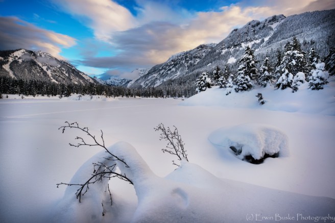
 Stepping Stones to Enchanted Autumn
In the above scene notice the stepping-stones in the foreground leading down to the lake. In the next image I decided to follow one of the granite slabs to an area above Leprechaun Lake and this created an optimal viewing platform and foreground that transported my eyes down the mountainside to the lake and McClellan Peak beyond. There is a strong line going from the right side of the image to the left that also forms a U shape curve in the lower right section of the image. The key is to make sure the foreground is well-integrated with the larger scene and do not just select the foreground because it is appealing in its own right. Orienting the scene around foreground will often make the composition look forced rather than bringing a more organic and free flowing feel to the image. Look at the scene and how it effects your mood and emotions, determine your intentions, and only then start working the technical details of focal length, specific foreground details, tripod placement, ISO, F-stop and shutter speed.
 Enchantments Sliding Rock
 Rock Formations
The classic composition in the Enchantments typically involves one of the prominent peaks reflected beautifully in the water of one of the lakes. But you can make yours more unique by also including attractive foreground elements and framing of the peak and reflection such as I was able to accomplish in the next image.
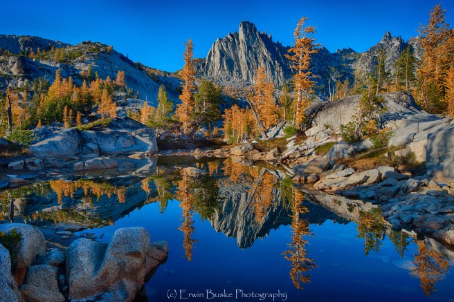
A telephoto zoom lens is indispensable for smaller area compositions that feature the lines and patterns of the granite slabs and boulders punctuated by blazing orange larch trees.. It takes some training of the eye to isolate an area of the larger scene that will make a good composition but it is well worth the effort because these compositions will be very unique and help balance out an Enchantment Lakes portfolio that is heavy on lake images. This is an area I plan to work far more in future visits to the Enchantments.
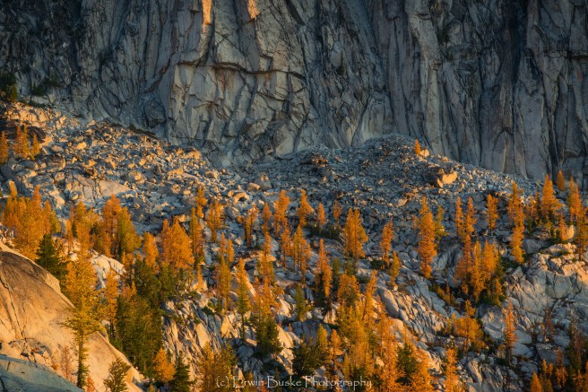
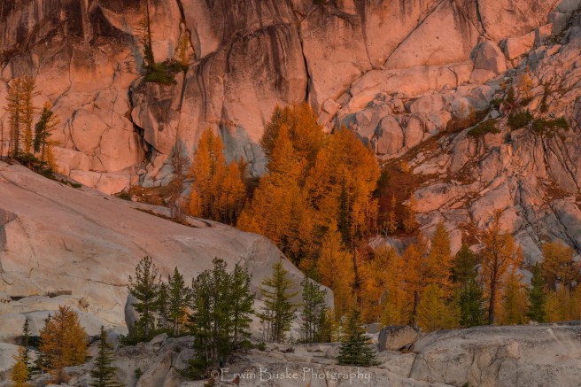 Autumn Larches below Granite Cliffs
A telephoto lens can also be used to capture even smaller subjects and details such as this next image of a snow-covered larch branch.

Lighting
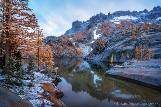
Most of the featured images I have seen of the Enchantments are taken at sunset which is a great time to capture soft light, and colorful dramatic clouds and skies. This, however, in my opinion is not the best time to capture well illuminated larches. I have found the best light to actually be about an hour after sunrise and about an hour before sunset. Digital enhancement and painting on light can only go so far if the light was not there in the first place. The lower Enchantment basin is deeply recessed beneath the towering peak and it is only then the light will penetrate low enough to sufficiently illuminate the larches to get the desired effect. The lighting will also be far more nuanced in this time period with areas of light and shadow. If there are clouds and mist in the area and the sun can still get through, the effects will be even more splendid.
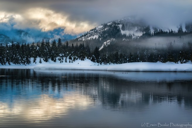
 Leprechaun Lake at Sunset
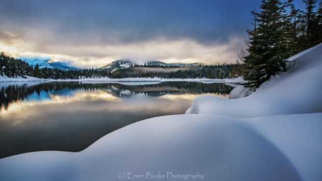
 Epiphany (Leprechaun Lake one hour after sunrise)
 Leprechaun Lake Tidelands (One hour after sunrise)
Fish and Wildlife
The lower Enchantment Lakes are teaming with trout, and this area is one of the best in the Alpine Lakes for the sports fisherman.
 Kris Harken’s Lucky Day
There are Mountain Goats in abundance at the Lower and Upper Enchantment Lakes. You can expect them to wander into your campsite in the mornings and evenings creating multiple opportunities for both wide-angle and telephoto capture.
 Guardian of the Camp
 Mama and Kid Goat checking out the intruders!
Larches
About one hour after sunrise and one hour before sunset the Larches are at their best. In this next image I captured a beautiful collection of side-lit larches reflected in a small tarn. It is also possible to find single specimens to capture the beauty and character of an ancient larch.
The Magic of the Enchantments
In this post I have expressed my own perspective about capturing the magic of the Enchantments. I hope some of what I wrote here will provide you some helpful guides as you follow your own instincts, personal vision and style in creating your own images that capture the Magic of the Enchantments. Thanks for looking, sharing and your comments are always greatly appreciated.


 Mazama Moment 28mm f-8 (focus stacked)
 Picture Lake Mountain Ash Purple Mountain Majesty 35mm f-11 (focus stacked)